You are here
WEEK 2
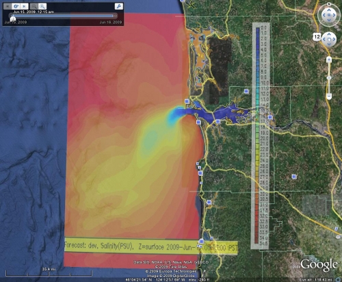
Well as for me, this week I have progressed to another level in kml. This time I focused on making things to move, in other words animations. I first worked with images which I grabbed directly from the CMOP website, where the amounts of salinity were displayed. Then I had to find a way to display those images through Google Earth in a way where one can see a visual interpretation of the amounts of Salinity moving into the Columbia River through a 24 hour period. The approach I took was by using <TimeSpan>. With <TimeSpan>, one can control the display of an image with a year, month, day, hour, minute, second, and timezone otherwise expressed as yyyy-mm-ddThh:mm:sszzzzzz. Below is a snapshot of the final outcome.
I also made an animation of the Glider by using points that the CMOP website provided. With the Glider I did have a bit of problems, because I was not sure of whether to use <TimeSpan> or <TimeStamp>. The KML reference page, by Google Code, suggested <TimeStamp> as the way to make points move in Google Earth. However, one difference between <TimeStamp> and <TimeSpan> is that <TimeStamp> displays a point, or image, for that exact given time. So if I wanted to display the glider moving from 3:00pm to 3:30pm using <TimeStamp>, the Glider would display at Google Earth at only 3:00pm, but at 3:01, 3:02, etc.. it would not be showing up, until 3:30pm arrives. Having this in mind, my choice for animating the glider was <TimeSpan>. As of now, the glider is nothing but a 2-d image. I discussed with my mentors some ideas that I have in mind for the appearance of the glider in Google Earth, but for now I won’t speak too soon. All I can say about that is that Google Earth can display 3-d images in motion.
Next after the glider, Alex told me to make a tour out of the North and South channels of the Columbia River. At first, I found it difficult to understand, because there are many variables which affect the movement, position, angle, direction, and altitude of the camera. One of the things I had a hard time with was finding out the latitude and longitude, because I had to use that in order to get the camera to move to certain areas that I wanted it in. On all the previous tasks I have done, I usually worked with coordinates, which I am very familiar with. However, today (Friday) I have finally figured out how to work with longitude and latitude effectively through Google Earth. Since the longitude and latitude are displayed in Degrees, minutes, and seconds, I had to convert those numbers into decimal that way Google Earth can read those numbers out of the kml file.
If interested or if you simply are skeptical about my work, download the attachments below and see for yourself! Oh yes, and as for the NSF site visit and the free food and all, I gotta say it was all good and interesting. Yes indeed very interesting.
| Attachment | Size |
|---|---|
| 624.67 KB | |
| 1.16 KB | |
| 821 bytes |

