You are here
Smart Kayak Gathers Biogeochemical Data in Shallow Waters
08/17/12 Portland, Ore.
Some areas in the Columbia River estuary are difficult or even impossible to monitor the biological activity that leads to plankton blooms and hypoxic waters. Traditional scientific observation tools - like moored platforms or expensive research vessels - are not feasible to use in shallow water.
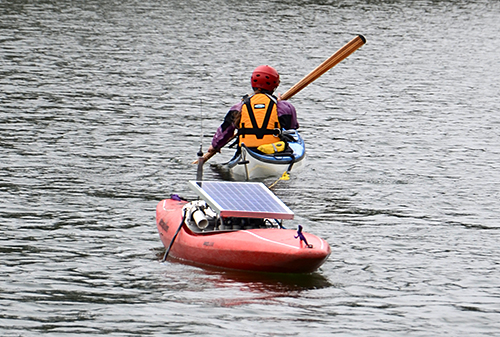
 Kiviuq collects data as Welle tows it in Baker Bay.
Photo by Jeff Schilling/CMOPScientists from the Center for Coastal Margin Observation & Prediction (CMOP) have developed a novel approach for collecting biogeochemical data in these areas. They equipped an eight-foot kayak with an array of sophisticated sensors and use it as an in situ mobile platform.
Alder Creek Kayak & Canoe, a paddle sports store and instructional center in Portland, donated the kayak. CMOP scientists have named it “Kiviuq” after a moon of Saturn and hero of Inuit mythology.
Kiviuq is deployed in Baker Bay, located on the Washington state side of the Columbia River, where spectacular red water blooms (Mesodinium rubrum) are first detected before extending across the estuary. Kiviuq hitches a ride around Baker Bay with two volunteer kayakers, Pat Welle and Tim Mattson. Welle is a Ph.D. student at Oregon Heath & Science University and Mattson is a computer scientist at Intel, both are certified professional sea kayak guides.
Welle expects many researchers at CMOP, including herself, will benefit from the new endeavor. “One of our research objectives is to attain measurements of key biological parameters on a spatial scale that cannot be achieved in traditional ways,” Welle said. “Kiviuq data will give us the ability to gain a better understanding of how the biological activity in the Baker bay modulates low dissolved oxygen in the estuary.“
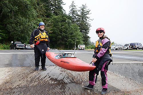
 Welle and Mattson prepare to launch Kiviuq.
Photo by Jeff Schilling/CMOPWelle and Mattson plan to tow Kiviuq bi-weekly during the summer and fall to capture changes in biological activity. The physical and biogeochemical water data they collect will be transmitted in real time to the SATURN Observation Network and used by scientists and modelers around the world.
Ben Li, Ph.D., OHSU post-doctoral scientist, is among those scientists that are excited about Kiviuq. “We don’t have many details about what happens in Baker Bay before a red water bloom occurs,” Li said. “The information from the kayak-based sensors will advance our understanding of temporal and spatial dynamics of the phytoplankton community, especially Mesodinium rubrum and its prey cyrptophyte algae. This is important for predicting when and where a bloom may occur.”
This is also the first time CMOP and modelers will have spatial and temporal measurements from the extremely shallow waters from lateral bays off the estuary. “We will now have data from areas in the estuary we have never had before to calibrate our current physical and biological models,” said Yvette Spitz, Ph.D., Oregon State University professor and CMOP investigator. “For example, information from the phycoerythrin sensor will allow us to follow Mesodinium rubrum and cyrptophyte algae from the bay into the estuary and fill gaps in our Mesodinium rubrum and biomass models.”
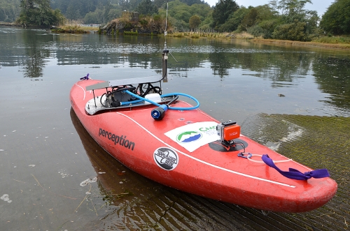
 The CMOP field team equipped the kayak with aquatic sensors, a flow-through system, GPS, and other instrumentation.
Photo by Jeff Schilling/CMOPBefore the research could move forward, the team had to assemble the one of a kind mobile platform. Michael Wilkin, OHSU senior engineer, and coordinator of the CMOP field team, was tasked with the challenging build. “The kayak needed to have a flow-through system like a research ship and low power system like a buoy, ” Wilkin said. “The challenge was keeping it small, waterproof and lightweight to fit in the kayak, while still being able to sample the water properly and transmit the data back via the Internet.”
Wilkin and the field team outfitted Kiviuq with advanced scientific instrumentation to measure dissolved oxygen, temperature, salinity, turbidity, fluorescence, and phycoerythrin on a real-time basis. Kiviuq operates as a flow-through system that allows water to move through the sensors flow cells and discharges the sampled water back over the side. The measuring cells are passive so nothing is added to the water and it is safe to release back into the estuary.
"The Kiviuq campaigns strategically address a gap in our scientific understanding of the role of lateral bays in the Columbia River estuary," said António Baptista, Ph.D., Welle's adviser and the CMOP director. "These campaigns are a testament to the power of team work, by a group of scientists from diverse institutions who learned to work together, thinks creatively, and has the benefit of an informative context of long-term, high-resolution observations and simulations."
Written by Jeff Schilling
About CMOP
The Center for Coastal Margin Observation & Prediction (CMOP) is a National Science Foundation Science and Technology Center. CMOP is creating a new paradigm for conducting coastal-margin science. The new paradigm is anticipatory rather than reactive, and is based on the emerging power of “Collaboratories”, structured integrations of information, observations, models and people. CMOP is a broad multi-institutional partnership led by Oregon Health & Science University, with Oregon State University and the Applied Physics Laboratory at University of Washington as anchor partners.


