You are here
Quinault Indian Nation Gains Better Understanding of Hypoxia in Ocean with the Help of Phoebe
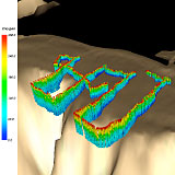
09/30/09 Portland, Ore.  Color 3D image of observed oxygen readings taken by Phoebe over the Washington coast bathymetry. Red represents higher levels of oxygen in the water. Blue represents lower oxygen levels. View more images.
In the summer of 2006, marine life was devastated by hypoxia (low-oxygen) in the coastal waters of the Quinault Indian Nation (QIN). Bottom fish were strewn across beaches. Crab pots were filled with dead crustaceans. The fishing economy that the Quinault people depend on was threatened by a hypoxic event.
Today the tribe is gaining a better understanding of hypoxia in their coastal waters with assistance from the Center for Coastal Margin Observation & Prediction (CMOP).
Coastal hypoxia is caused by oxygen depletion in coastal waters due to microbial respiration of organic matter. When temperature and water column mixing create conditions of high oxygen removal the environment becomes inhospitable for fish and mammals.
“This is a worldwide phenomenon that is increasing in severity in many regions due to human activities that release nutrients into the coastal ocean and stimulate algae growth,” said Joe Needoba, a CMOP scientist. “However, in the Pacific Northwest we have a more complicated scenario, where wind driven circulation and transport of low-oxygen waters onto the continental shelf fuels hypoxia formation. The right combination of deep water transport and coastal productivity during summer can cause severe hypoxia along the coast. “
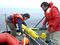
 Katie Rathmell and Michael Wilkin prepare to launch Phoebe. View video of Phoebe's deployment.Joe Schumacker, QIN marine scientist, is partnering with CMOP to understand the complex ecological process that causes hypoxia. He is utilizing the center’s underwater glider named “Phoebe” to identify the low-oxygen zones in the tribe’s traditional ocean waters.
Phoebe is a Slocum 200m underwater glider equipped with a variety of sensors. She has the ability to monitor physical, chemical and biological parameters associated with hypoxia formation.
“Phoebe gives us a look at a large piece of the ocean that we really never have been able to get good information on,” Schumacker said.
This research effort is a perfect example of what CMOP is accomplishing with coastal margin ‘collaboratories’. The center is using dedicated teams to ensure the glider is deployed, data flows in real-time to users, and predictive models add value and improve the data.
“We are exploring ways by which both scientists and regional stakeholders, in this case the Quinault Indian Nation, influence where we deploy gliders and other observation and prediction assets,” said António Baptista, director of CMOP. “We aim to ensure that the data we collect and the simulations we conduct add effective value to our common knowledge of the Pacific Northwest coastal margin.”
Schumacker, QIN tribe members, and CMOP scientists are studying data sent back from Phoebe. The information is giving them a more detailed look at where the low-oxygen water is coming from and may enable them to predict hypoxic events in the future.
“The best thing in situations like this is to have all the information you can gather,” Schumacker said. “If there are changes coming to the environment, it is good to know about them coming before they hit.”
Written by Jeff Schilling
# #
The People of the Quinault are among a small number of Americans who can walk the same beaches, paddle the same waters, and hunt the same lands as their ancestors did centuries ago. The Quinault Indian Nation (QIN) consists of the Quinault and Queets tribes and descendants of five other coastal tribes: Quileute, Hoh, Chehalis, Chinook, and Cowlitz.
Phoebe data are available in near real-time and in archival mode, to scientists like Joe Needoba and managers like Joe Schumacker, as well as to the public at large. Many contribute for this to happen. Katie Rathmell and Michael Wilkin maintain and deploy the glider, with on-site vessel support provided by Tribal fishers. Charles Seaton plans the glider routes, and with Alex Jaramillo, Paul Turner and David Hansen, shepherds data in real-time from the glider to the web. Joe Cho, Joseph Zhang and Nate Hyde produce numerical simulations along the glider routes. Antonio Baptista provides scientific direction.
View Phoebe Data: www.stccmop.org/datamart/observation_network/glider


