You are here
Research
Society requires a better scientific understanding of the potential effects that climate and human activity will have on coastal margin ecosystems, to ensure positive outcomes for environmental sustainability, economic development and public health.
The CMOP research mission is to conduct studies and develop technology that provide a sound foundation for predictive coastal margin science, and that serve as a catalyst for our educational, knowledge transfer and broadening participation missions
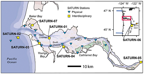 The Columbia River lower estuary, in geographic context. The Navigation and North channels, shown in darker blue, are dominant features. Yellow squares and cyan triangles represent stations of the SATURN observation network. The blue lines in the inset are hydrographic lines (Grays Harbor and Newport, from North to South) of NSF’s planned Ocean Observing Initiative (OOI). The Columbia River lower estuary, in geographic context. The Navigation and North channels, shown in darker blue, are dominant features. Yellow squares and cyan triangles represent stations of the SATURN observation network. The blue lines in the inset are hydrographic lines (Grays Harbor and Newport, from North to South) of NSF’s planned Ocean Observing Initiative (OOI). |
Our research is focused on the coastal margin influenced by the Columbia River. The Columbia River is the largest river entering the Pacific Ocean from the United States, with a watershed that includes seven states and two provinces of western Canada. The river flows into one of the earth’s several Eastern Boundary Current Ecosystems (the California Current Large Marine Ecosystem), which are characterized by coastal upwelling and high oceanic productivity. The Columbia River has an annual average discharge of 7,500m3/s (70% of the freshwater input to the Eastern North Pacific between the Strait of Juan de Fuca and San Francisco Bay), and is regionally important for fisheries habitat, power production, transportation, industrial development, and many other ecosystem services.
Science Initiatives
We organize our research through four anchoring Science Initiatives that rigorously address ecological hotspots and ocean-estuary exchanges that control the function of the estuary as a bioreactor. We use the concept of "estuarine bioreactor” as the summation of the effects of the ecological hotspots, ocean-estuary exchanges and river forcing on nutrient cycles and energy flow at an ecosystem scale. The concept ultimately represents a means to quantify many of the ecosystem services that estuaries provide and through which estuaries contribute to the well being of society.
Learn more about the Science Initiatives
SATURN collaboratory
All initiatives are supported by the infrastructure of the SATURN collaboratory, a synergistic scientific integration of sensors, models, people, and multi-directional information flows. The SATURN collaboratory includes: (a) integrated observations of physical and biogeochemical variables at endurance stations, gliders and autonomous underwater vehicles; (b) an operational modeling system (Virtual Columbia River) skill-assessed against observations, and fast evolving in disciplinary scope; and (c) the philosophy and practice of free flow and quality control of information across sensors, models and people.
Learn more about the SATURN collaboratory

